Readers of James Churchward’s works will remember his theories of the recent raising of the mountains and the draining of the Amazonian Sea in South America.
From Children of Mu, page 22
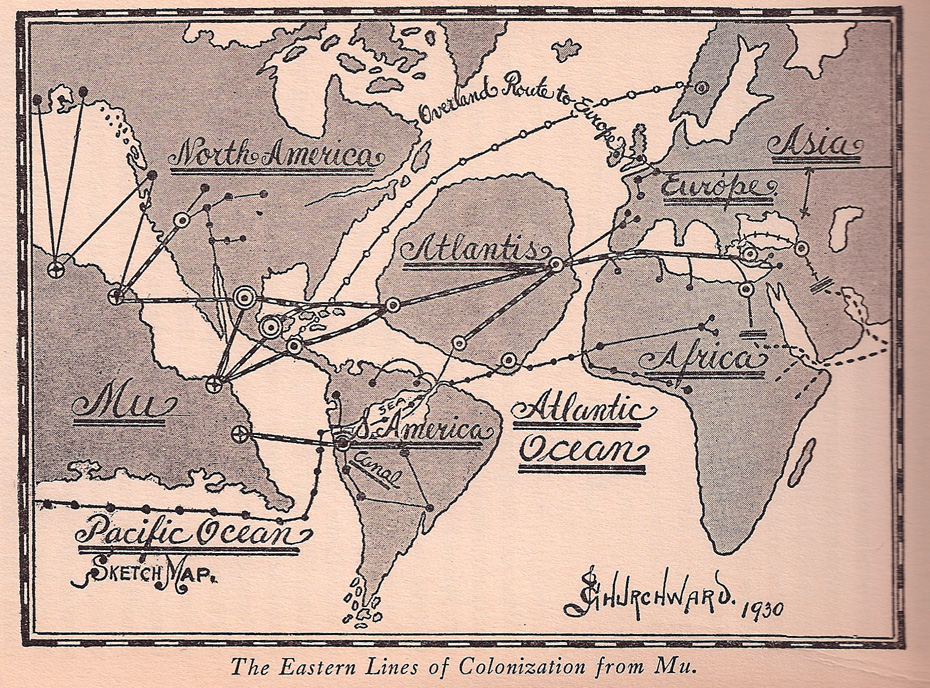
THE ANCIENT.—And now, to me, comes the most fascinating part of South American history—the distant past. Strange as it may appear to us today, the fact remains that in ancient times South America played an important part in peopling the world, for she was the road or passageway that two important lines of colonists took going from the Motherland in easterly directions. The topography of South America today is totally different from what it was 20,000 years ago, the time when droves of Carians, or Karians, and Negro colonists were leaving the Motherland to find new homes and more room upon the earth. When this exodus from the Motherland commenced we have not as yet been told, but there are various records of emigration some 35,000 years ago and others 70,000 years ago. Then South America was like the rest of the world—flat and without mountains—for up to less than 15,000 years back no mountains had been raised to protect man from constant destructions by cataclysms and submersions, nor could there possibly be until after the earth went into Final Magnetic Balance.
What is now the Amazon Valley, which is intended to include the Amazon Swamp and the Amazonian watershed, was then an equally large land-locked Sea like the Mediterranean Sea today. The Amazonian Sea at its eastern end was connected with the Atlantic Ocean and at its western end with the Pacific Ocean by canals. These canals were intact up to the time the mountains were raised. There was an uninterrupted waterway between the Motherland and Atlantis, West Africa, and even as far as Asia Minor at the eastern end of the Mediterranean. The shore lines of this Amazonian Sea are very distinctly marked today: the northern shores were along the foothills of the Venezuelan highlands; along this shore line are some wonderful white quartz beaches. The southern shores are along the foothills of the Pan Alto Mountains. The eastern shores are along a mountainous spur that runs into the Pan Alto, and the western shores are along the eastern foothills of the Andes.My attention was first called to this Amazonian Sea by one of the before- mentioned tablet maps in the monastery in Tibet. I discovered that these maps were dated. Their dates were given by the position of certain stars in certain constellations.
Children of Mu, pages 90-91

Colorized map seen by Churchward in Tibetan monastery
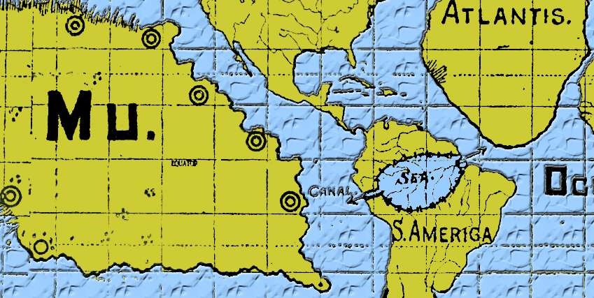
Colorized map seen by Churchward in Tibetan monastery – with closeup on Amazonian Sea
Unfortunately, a new study has shown the Amazon River is no younger than 9 million (9,000,000) years old by examining the contents of hydrocarbon exploration boreholes. The evidence clearly shows the change in sediment composition and plant residue from 9.4 to 9 million years ago switching from the tropical lowlands to the high Andes Mountains.
The new study shows James’ age of orogeny (it is the word of the day) is completely off-base. Mountains took millions of years to be created and did not pop up ‘overnight’ in geological terms.


 RSS - Posts