Another article from James Churchward’s scrapbooks…
Los Angeles Herald Feb. 5th 1931
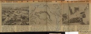
New Zealand Quake Recalls Cataclysm Of ‘Lost Continent’ Mu
Through the ages, restless South Seas lands have suffered from cataclysmic outbursts of Nature, as North Island of New Zealand is suffering from devastation by an earthquake. At Napier, pictured above, Bluff Hill slid into the harbor, shown in the background, then the bottom of the harbor arose and the steamers’ anchorage pool, ‘The Ironpot,’ turned upside down and became an island.
New Zealand lies just south of location of the supposed “lost continent” Mu, as shown in this theoretical map. Some scientists believe that great volcanic upheavals sank Mu in the long ago, leaving only peaks which are the islands of Hawaii, the Ladrones, the Fiji isles and others. They think that Mu served as a ‘land bridge’ across the Pacific, for tablets found on the islands resemble Egyptian cuneiform writing and the ruins resembled architecture of the ancient Mayans.
This picture shows a typical scene in an earth disturbance and volcanic eruption in a southern land. Such a disaster is believed to have occurred in the sinking of Mu with its ancient civilization. History repeated itself in part when the earthquake struck North island of New Zealand, a place of rumbling volcanoes, thermic lands and buried fires, and laid two cities in ruin.


 RSS - Posts